Kopano Mineral Resources LTD (“Kopano”) is Zambian registered wholly owned subsidiary of Beltz Mining, a privately owned Australian company headquartered in Perth, Australia.
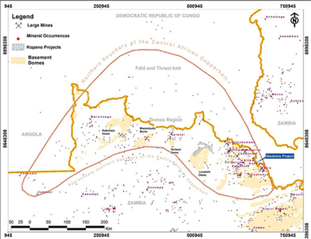
Kopano has a growing number of highly prospective tenement holding situated in the Zambian portion of the Central African Copperbelt – one of the greatest repositories of copper and cobalt deposits the world has ever seen.
The Zambian portion of the Copperbelt boasts of several high-tonnage, high-grade stratabound copper-cobalt deposits occurring at various stratigraphic horizons within the Neoproterozoic age metasediments.
Notable deposits of the Copperbelt belt include the following:
- Sentinel – 1190 million tonnes at 0.5% copper
- Kansanshi – 745 million tonnes at 0.86% copper
- Lumwana – 738.5 million tonnes at 0.66% copper
- Nkana – 690 million tonnes at 2.5% copper
- Konkola – 685 million tonnes at 3.1% copper
- Nchanga – 580 million tonnes at 3.6% copper
- Mufulira – 335 million tonnes at 3.3% copper
- Luanshya – 290 million tonnes at 2.8% copper
- Frontier – 289 million tonnes at 1.16% copper
- Chambeshi – 240 million tonnes at 2.3% copper
- Chambeshi southeast – 117 million tonnes at 1.87% copper
Kopano’s current exploration permits covering a total of 300 square kilometres, providing a great combined potential for near-term discovery and production growth opportunities.
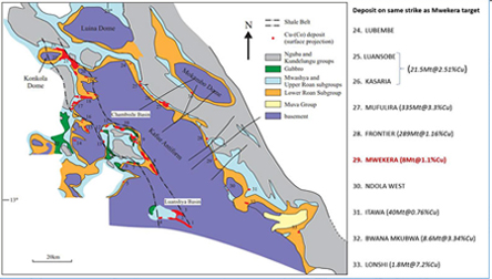
The Mwekera Project covers a 7.5km mineralised belt surrounding the existing Mwekera mine and includes zones similar to the Frontier Copper Mine in the DRC (~85,000 tonnes of copper annually)
Based on historical data and USGS, Mwekera suggests a non-compliant resource of over 10Mt copper at 1.53%TCu.
The geology of the project supports large-scale extraction, backed by strong historical data and geochemical and geophysical surveys completed to date indicate significant copper mineralisation potential.
Results from work carried out by Beltz Mining to date align with historical data and reinforce confidence in the resource scale and quality. Beltz has identified two distinct target styles through Pole-Dipole Induced Polarisation (PDIP):
- Target Area 1 – Roan style: Three distinct chargeability anomalies identified: Zones A, B, and C
- Target Area 2 – Frontier style: Strong, well-defined chargeability anomaly identified in the NE quadrant (Zone C)
Beltz is scheduled to commence a 4000 – 5000m initial drilling program to identify mineralised zones.
The Mwekera Project occupies ground situated to the east of the Kafue anticline and lies along strike of the well-known Mufulira, Frontier, Bwana Mkubwa (8.6 million tonnes at 3.34%Cu) and Lonshi copper (1.8 million tonnes at 7.2%Cu) deposits. Along this same trend, there are several other lesser known copper deposits identified in the past and still yet to be exploited, including:
- The Kasaria-Luansobe (21.5 million tonnes at 2.51%TCu Freeman, 1988),
- The Nsato deposit (8.4 million tonnes at 1.61%Cu Freeman, 1988)
- The Mutundu North deposit (4.3 million tonnes at 1.44%Cu)
- The Itawa deposit (40 million tonnes at 0.76%Cu)
Apart from the Mwekera Project occurring in the known and proven mineral district, the Project has historical exploration records which add credence to the area’s prospectivity. Past drilling identified copper mineralisation at several stratigraphic horizons within the Katangan strata; with 3 main zones of economic copper defined within the Roan group of the Katanga supergroup. was estimated using 40 diamond cored boreholes. The copper resource is situated between 100 – 500 m below the surface.
The estimated resource comes from drilling data which covered only a 2.4 km portion of the Mwekera concession, out of the available 7 km of untested Lower Roan rocks. As such, Beltz believes there is excellent room and potential to expand the resource when the entire prospective ground is drill tested thoroughly.
The Mwekera Project is located in the Neoproterozoic Lufilian which straddles parts of eastern Angola, southern Congo DR, northwestern and Copperbelt provinces of Zambia. It is a convex shaped region that extends for over 800 km and hosts all copper and cobalt resources of the Central African Copperbelt (CCB). Scholars have subdivided the Lufilian Arc into 4 main sub regions thus: (i) External fold and thrust belt, (ii) the domes region, (ii) the Synclinorial belt, and (iv) the Katangan high.
The Mwekera project lies in the domes region, a Neoproterozoic metallogenic province which hosts several world-class copper-cobalt deposits of the Central African Copperbelt (Zambia and Congo DR). Copper deposits found in this region show many characteristics consistent with their classification as stratabound/stratiform sediment-hosted deposits. Sediment-hosted deposits are so-called because they are confined to specific narrow layers within a sedimentary sequence but do not necessarily follow sedimentary bedding.
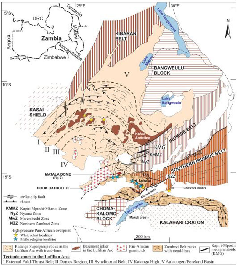
In the Copperbelt, these deposits are localised in intracontinental rift basins which culminated from extensional tectonics of the pre-existing paleoproterozoic basement with subsequent crustal shortening of the basin-fill during the Pan-African orogenic event. The basin fill are collectively referred to as Katangan supergroup sediments which are further subdivided into the Roan Group (Lower and Upper), Mwashia and Nguba. The basal Roan Group consists of early-rift stage continental siliciclastic “red beds” (Lower Roan) underlying evaporitic carbonates and siliciclastic rocks (Upper Roan) which in turn are overlaid by marine siliciclastics and mafic igneous rocks of the Mwashia Group.
Copper mineralisation occur in multiple lithologies and stratigraphic positions and vary in type of mineralisation and alteration, but share vital characteristics. Deposits occur at the lowest redox boundary within reduced facies rocks above oxidised facies rocks. This redox boundary may be stratigraphically or structurally controlled, consequently is positioned at different levels throughout the CACB. Many deposits are positioned in the vicinity of macro-structural features, primary growth faults and large anticlines and synclines formed during Lufilian inversion of such faults.
Source of metals in the Katangan basin is generally thought to come from the basement but ideas on how and when they got to present deposition sites abound. Some scholars postulated metal source to be from convective recirculation of hot basinal fluids driven by high geothermal gradients associated with crustal rifting in the Lufilian (epigenetic model). Many others believe metals were derived from erosion of basement with sediments transported in rivers and adsorbed on clays and deposited contemporaneous with host rocks (Syngenetic model).
The widely accepted genetic models are the early, intermediate to late diagenetic models which developed from studies of diagenetic processes in sedimentary rocks (Brems et al., 2009; Sillitoe et al., 2017; Sweeney and Binda, 1989). These models contend that sulphides were precipitated during large-scale chemical reaction of host rock and its pore fluid with metalliferous brine (Bartholome et al., 1971; Annels, 1984; Selley et al., 2005; Unrug, 1988). Copper and its accompanying cobalt or silver were introduced during diagenesis of the host sediments (Brown, 1997; Hitzman et al., 2005).
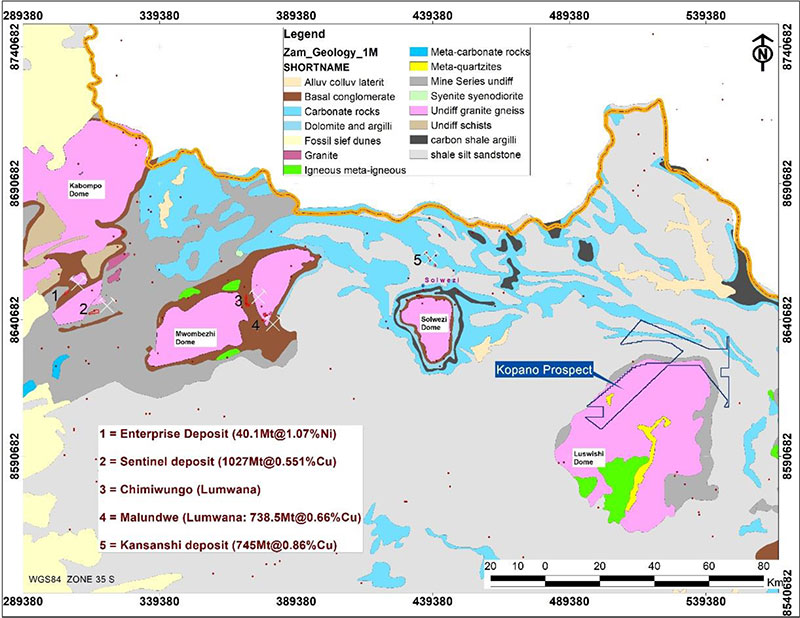
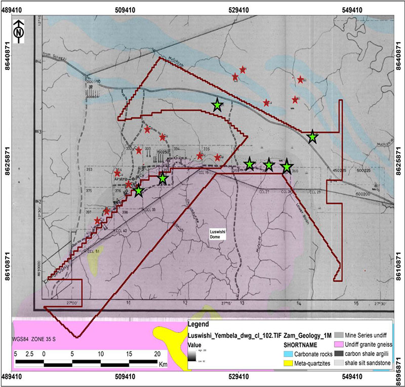
The Luswishi concession covers 553 square kilometers of exploration ground on the northern and northwestern flanks of the Paleoproterozoic Luswishi dome. This dome has an inner core of granite-gneiss rimmed on the outside by Neoproterozoic metasedimentary rocks (Katangan Supergroup). This portion of the dome has been subjected to continuous exploration since the early 1950s when auger drilling revealed presence of anomalous copper in near-surface soils exceeding 1% over strike length of nearly 2 km. Follow up diamond drilling programmes confirmed presence of copper ore in the Roan Group where it occurs as chalcopyrite in calcite veins, similar to how it occurs at First Quantium Minerals’ nearby Kansanshi deposit (745Mt@0.86%Cu, with Au credits) situated 81 kilometers to the west.
At Kansanshi copper-gold deposit, mineralisation occurs in 3 dominant styles as follows;
- Steeply dipping, sheeted quartz-carbonate-sulphide veins,
- Sediment-hosted, mineralised haloes to the veins, and
- Sulphide crackle and stockwork breccias in zones of higher veining density.
The veins range in thickness from a few millimeters to about 6 m and are predominantly vertical to subvertical trending in diverse directions but in general they follow the NW-SE trending zone. Individual veins mostly have N-S trends and strike lengths vary from hundreds of metres to about 1.2 km with widths of roughly 200 m and vertical dimensions not exceeding 300 m deep.
Similarly, copper mineralisation at Kopano’s Luswishi project occurs dominantly as chalcopyrite in calcite veins which have thicknesses varying from 10 cm to about 10 m with grades ranging from 0.94% copper to 11.71% occurring at depths of between 80 – 600 m in Upper Roan dolomites. Roan Selection Trust (RST) in the 1960’s cored a total of 14 boreholes targeting stratiform mineralisation in the Lower Roan, 9 of which intersected copper mineralisation. The drillholes went through Upper and Lower Roan group rock units before terminating in the granite-gneiss basement. Inspection of the core revealed the Upper Roan carbonates have higher magnetic susceptibilities and hosts fine disseminations and blebs of chalcopyrite and bornite. These 9 cored boreholes were later utilised to compute a crude resource estimate amounting to 800,000 tonnes copper grading at 2.2% (WGM, 1991).
RST collected good gridded data along the Basement-Katanga contact in the northern flank of the Luswishi dome (Luswishi project). Their targeting exploration model was stratiform deposit styles. Stream sediment sampling was conducted alongside machine auger drilling. Stream sediment assays revealed anomalous cobalt concentrations ranging between 5.8 – 32.9 ppm. In the northwest corner of the Kopano licence (RST’s sheet 376) a highly anomalous area was outlined by auger drilling with values of copper up to 12,600 ppm and values of cobalt maxing at 2600 ppm. These results so motivated RST that they hurriedly sunk in some boreholes such as RGL4 without ground magnetic and IP geophysical support and therefore its possible they could not have tested the most sulphide-rich parts of Luswishi north (WGM, 1991).
To understand the significance of the soil and stream sediment results obtained in Luswishi project, a comparison with geochemical surveys conducted on the some of the Copperbelt deposits in the 1950’s is useful. These surveys established background and anomalous values of copper and cobalt in freely drained soils. For example at Luansobe, northwest of Mufulira, anomalous range of 150 – 400 ppm Cu over 300 m-thick deeply leached soils overlying ore mineralisation with 25 – 100 ppm Cu established as background. Similar ranges were obtained in Lufubu North on soils overlying sub outcropping ore (200 – 550 ppm Cu anomalous) with background values in the range 30 ppm to 75 pp copper. Anomalous cobalt range overlying orebodies was established to be between 20 – 80 ppm with background values in the range 7 – 14 ppm. As long as the peneplain topography was flat anomalies peaked directly overlying sub outcropping mineralisation.
Overall, the Luswishi project has good exploration data generated by past explorers that is available for review to aid new exploration. These data sets include:
- Good gridded geochemical data
- Falcon/BHP/FQM/Vale and Anglo Spectrem geophysical data
- Airborne magnetics and radiometrics data at 400m spacing
- Historical drillholes stored at the chamber of mines/ZCCM-IH core yard in Kalulushi ∙ Recent drillholes completed by Vale (stored in Kalulushi/Geological survey)
